Project Objectives
East End Pond Langtoft Lincolnshire – Restoration Project
This project is being undertaken by Pete Coles, a resident within the village who is very keen on nature conservation, and was part of the group that assessed Penfield Nature Reserve when it was in its infancy. His vast past experience has enabled him to build excellent working relationships with other Nature focused societies, e.g. Lincs Wildlife Trust, Langdyke Trust to name just a couple.
Topography of the pond
The rectangular pond is within the Langtoft conservation area and measures approximately 70mx30m. The floor of the pond is approximately 3m below the surrounding ground level. The pond is situated within the boundaries of a small recreation ground.
The entry in the Lincolnshire County Council heritage records reads:
Reference Name MLI33453
Description:
PRN 33453
A LARGE SUB-RECTANGULAR FISHPOND SOUTH OF THE FARMHOUSE AT LANGTOFT HALL IS PROBABLY A LATE C18/EARLY C19 LANDSCAPING FEATURE. NOT MARKED ON THE 1792 ESTATE MAP, BUT APPEARED ON THE 1813 ENCLOSURE MAP. {2}
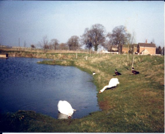
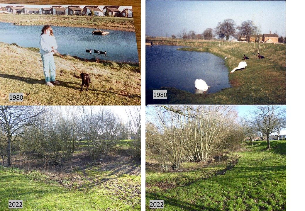
In the 1980’s the pond regularly filled with water although this was subject to seasonal variations. These photos show what the site was like in the 1980s with a comparative view today: -
Environmental impacts since the 1980’s which may have a bearing on the current water level in the pond: -
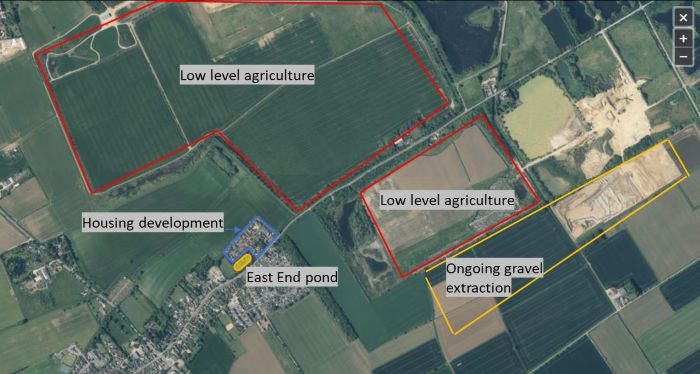
Gravel extraction
Gravel extraction in the surrounding landscape has been ongoing for the past 30 years. Where extraction has been completed then the land is either restored to low level agriculture or as water-based recreation and nature reserves. Much of this surrounding land is subject to drainage operations to allow for further gravel extraction and also to ongoing Internal Water Management to prevent flooding of the low-level agricultural land. This will have an impact on the depth of the current water table in the vicinity of the pond.
Housing development
The surrounding farm land to the north and east of the site was developed for housing in the late 1990’s (Barn Owl Close). Prior to this, rain water which fell in that area would have contributed to the water table and potentially flowed into the pond. Majority of rain water falling in that area is now captured by the sewerage system and transported away from the site.
Pond management
Since the 1980’s the pond has had very little proactive management and it is now overgrown with willows and other trees together with wetland plants. A large willow tree is thought to consume around 80 to 100 gallons of water a day. The presence of the 10+ willow trees in the pond basin will be affecting water levels.
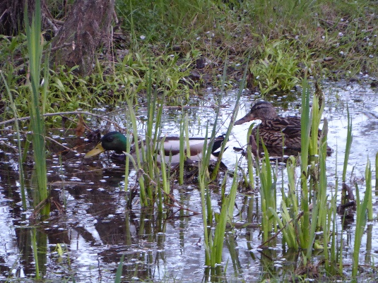
The pond area is thought to have been home to protected amphibians e.g., crested newts.
Vision and Restoration Proposal
In preparing this report, on-site surveys have been undertaken with John Oliver of Lincs Wildlife Trust and a web-based consultation with Carl Sayer of University College London.
The view from both LWT and UCL is that, due to the environmental factors outlined above, it’s unlikely that we will ever see water at levels seen in the 1980’s. However, the site can be actively managed to improve the current water levels and enhance the biodiversity of the site. That is what this proposal aims to achieve.
The vision is to bring the site back to its historic open landscaped area, retain and improve the seasonal water levels, and improve biodiversity by: -
- Removing/pollarding 70% of the trees particularly those in the basin which will allow light to penetrate the pond area. Ivy will be encouraged to grow on the pollard trees providing a much-needed nectar source during winter.
- Removal of dead vegetation from the pond basin thus improvinging the oxygen levels in the water.
- Removing scrub and brambles from the perimeter and sides of the pond and restore/recreate wildflower grasslands by the spreading of green hay.
- Installation of structures that provide environments suitable for birds, mammals and amphibians.
Project Plan
Please realise that the following activities are all dependant on the werather, availability of volunteers, possible funding etc. Hence some wishes may moved either to the preceeding or following year.
Year 1 – 2022/23
April
- Implement a minimal grass mowing regime around the pond to create a more nature friendly environment. i.e., stop mowing between end of March and late August. Allow the grass to grow but maintain a 1.5m wide mown grass path around the circumference of the pond but within a wild meadow area.
- Repair the bench on the north side (replace the back support). Demonstrates that changes are happening and that the site is now going to be managed.
- Take cuttings from the fondly remembered, burn damaged willow situated on the north west corner of the pond. To be grown-on and planted elsewhere within the parish.
May-June
- Conduct Great Crested Newt surveys.
July-August
- Introduce Yellow Rattle seed (collected locally) to the unmown area as a first step into creating a wildflower rich area.
September - March
- Pollard/remove the trees which sit within the pond basin (10+ mainly willows). Leave stumps of approx. 3m tall as ivy clad features.
- Create a hibernaculum (Wildlife log pile) on the North West slope using the cut willows. We should deliver this as a workshop, the community builds the hibernaculum with a couple of examples of what people can do in their own garden. Give a home for wildlife this winter and link it into feeding wildlife for winter focusing on importance of Ivy as a nectar source.
- Remove saplings, scrub and brambles from pond embankment.
- Chip waste material
- Mow grass and pathway surrounding pond
- Scrape trial trenches in pond basin to assess depth of dead vegetation and find marl layer.
- Assess water table levels
Year 2 - 2023/24
April-June
- Conduct additional Great Crested Newt surveys.
July-August
- Cut green hay at donor site, transport green hay and spread at the pond site.
September-March
- - Remove selected trees from around the pond embankment – chip waste material.
- - Remove dead vegetation from the pond basin and shape the pond floor so as to create a mosaic of smaller ponds within the larger pond/islands at low water levels. Excavated debris to be spread on the sloped sides to lessen the gradient. This work will require a JCB/small digger. (We could run this almost as a workshop and have information on building garden ponds for the public available either build your own with a couple of examples from tyre pond, sink or bath tub pond to liner/clay lined. We should also have information on a couple of local contractors who are able to build these for people. The aim here is to spread the concept of ‘ponds for wildlife’ and give people the idea and confidence to build their own garden pond).
Year 3 - 2024/25
September-March
- Construct and erect a swift tower. This will be part of a wider Swift, Swallows and House Martins project to be rolled out across Langtoft, Baston and Thurlby.
- Construct a duck house on duck island
- Position additional bench in a suitable location
- Undertake continuing scrub and vegetation maintenance
- Potentially erect picket fence and gate along boundary between the play and pond areas (for H&S reasons).
Summary
This proposal provides an opportunity to try and restore the pond area to something akin to its historic topology whilst working within the constraints of the current environmental impacts. At the same time, it also tries to improve biodiversity beyond that which existed in the 1980’s.
In terms of restoring water levels, it is not possible to say with any certainty how well this will be improved – only time will tell. But this proposal does provide a low cost considered attempt at achieving that ambition.
This project will aim to inspire a ripple effect across the village to encourage the wider public to enhance their own gardens for wildlife.